Apple Mapsを構築し、自律運転をテストするシステム Apple EyeDrive とは?
Meet Eyedrive, Apple’s system for building Maps and testing autonomous driving
Apple has been operating vehicles equipped with advanced sensors for some time, which are dedicated to collecting data to enhance Apple Maps. 9to5Mac has now learned exclusive details about how Apple uses these vehicles and manages such data.
Appleは進歩したセンサーを装備した乗り物をしばらく運営してきました。それはApple Mapsを改善するためのデータを集めるためのものです。 9to5Mac はAppleがどのようにこれらの乗り物を使用して、データを管理しているかについて、独占的な詳細を知りました。
- exclusive details - 「排他的な詳細」、「独占的な詳細」つまり9toMacが独占情報を得たということなんでしょう。

Sphero RVR(ローヴァー) 車型 プログラミング ロボット STEM/光センサー/赤外線センサー/ジャイロスコープ 搭載【日本正規代理店品】
Sphero
新品 ¥30,118 ![]() 6個の評価
6個の評価
Amazon.co.jpで詳細を見る
Twitter user @YRH04E shared with us some internal Apple materials that reveal how the company operates those special cars with sensors and the protocols that the Apple Maps team must follow to capture images and other data across the streets.
Twitterユーザー@YRH04E がいくつかのApple内部の素材を私達と共有しました。 それは、同企業がそれらの特別な自動車をどのように運営しているかや、Apple Mapsのチームが画像をキャプチャするために従わねばならない手順、また、道路に関する他のデータです。
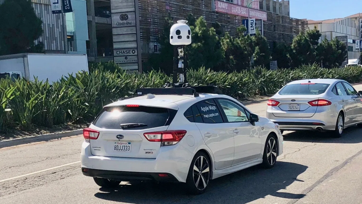
Apple began collecting data using modified vans, but now field operators drive a white Subaru Impreza, which is internally known as “Ulysses.” These vehicles are part of Apple’s 3D Vision team, which is responsible for combining multiple data with computer vision and machine learning technologies to provide 3D images on Apple Maps.
Appleは改造したバンを使ってデータを集め始めましたが、今は現場のオペレーターは白のスバルインプレッサを駆っています。これは内部では「Ulysses」として知られています。 これらの乗り物はAppleの三次元映像チームの一部で、AppleMapsに三次元の画像を提供するために、コンピュータービジョンと機械学習テクノロジーで、複数のデータを組み合わせることの責任を持っています。
The car is modified with dozens of hardware parts, including a tower at the top of the vehicle with advanced high-resolution cameras and Zeiss lenses, LiDAR scanners, and a 2013 Mac Pro that processes all captured data in real-time. Everything is controlled by the EyeDrive unit, which is a modified iPad with the EyeDrive app that provides the assignments to be done and also allows operators to manage captured data.
この車は多くのハードウェアの部品により改造されています。車の上部にあるタワーには進歩した高解像度のカメラとツァイスのレンズがあり、LiDARスキャナや、リアルタイムにキャプチャーデータを処理する Mac Pro 2013 などです。 全ては、このEyeDriveユニットにより制御されます。これはEyeDriveアプリをインストールした改造されたiPadで、実行のための割当を提供し、さらにオペレーターにキャプチャーデータの管理を許可します。
The vehicles are also equipped with 4 SSDs of 4TB each, which are filled up in about a week of work, and Apple relies on UPS overnight delivery to replace these SSDs as quickly as possible. The other type of car is a self-driving Lexus used for Apple’s autonomous vehicle efforts, which has the code name “Tyche.” Each modified vehicle has its own version of the EyeDrive app as you see below:
この乗り物はまた、4つの4テラバイトのSSDを装備しており、おおよそ1週間分の仕事で満たされており、Appleは、できる限り素早くこれらのSSDを置き換えるためにUPSが一晩で配送することに依存しています。 他のタイプの車はレクサスです。これは「Tyche」というコード名の、Appleの自律運転車への取り組みに使用されています。 それぞれの改造車は以下に見られるような、それ自身のバージョンのEyeDriveアプリを持っています。
EyeDrive
— andrey (@YRH04E) August 3, 2020
(the software used in vehicles that gather data for Maps) pic.twitter.com/sRAXoCB8jA
Apple keeps its modified cars in a safe and undescribed location, which is rented to a front company to maintain the anonymity of the real owner of the vehicles. Ulysses units are typically operated by a driver and another person who manages the EyeDrive system, and they have precise instructions to collect the data.
Appleはその改造車を安全に維持しており、その位置は明らかにしていません。 それは車両の現実の所有者の匿名性を維持するためにフロント企業に貸し出されています。 Ulysses ユニットは特にドライバーとEyeDriveシステムを管理する他の人によって運用されています。
The team must start the capture in the morning when the sun is at 30 degrees and drive until when it’s reaching 30 degrees at night, otherwise the sun interferes with how the LiDAR sensors work. Apple also requires that captures must be taken in perfect weather conditions in order to provide consistent images. Each car is carefully inspected before field work to ensure that all equipment is working as expected.
このチームは、太陽の角度が30度の高さにある朝のうちにキャプチャーを始めなければなりません。そして、夕方太陽が30度の角度になるまで運転しなくてはならないのです。 そうでなければ、太陽がLiDARセンサーの動作と干渉します。 Appleはまた、首尾一貫した画像を提供するために、キャプチャーは完全な天候条件で撮られるべきであると要求しています。 各車両は、すべての機器が期待通りに動作することを確実にするため、現場に出る前に注意深く検査されます。
- interferes - 干渉する
Once they’re on the road, the EyeDrive app on iPad tells the team where they should drive to capture data. The operator can check the images through the iPad in real-time and confirm if the capture looks good or if it has any issues. The streets where the car is driven are marked with a green outline, and the operator can mark if a specific street cannot be accessed either because it’s a private area or a road under construction.
ひとたびそれらが道路に出れば、iPadのEyeDriveアプリは、このチームに対して、彼らがデータをキャプチャするために運転すべき場所を通知します。 オペレータはiPadでリアルタイムに画像をチェックでき、キャプチャがうまく言っているのか、あるいは、なにか問題があるのかを確認できます。 この車両が運転している道路は、緑の線でマークされますし、オペレータは特定の道路がプライベートな領域であったり、工事中などでアクセス不能な道路であるかどうかのマークをつけられます。
At the end of the day, the systems are turned off and everything is safely saved. The car is once again inspected and the SSDs with captured data are immediately sent to Apple.
一日の終りには、このシステムは電源を落とされ、全てが安全に保存されます。 この車両は再び検査され、そのキャプチャーデータの入っているSSDは直接Appleへ送られます。
All that data is mainly used to enhance features like Flyover and Look Around, where users can explore 3D cities on Apple Maps. These vehicles are commonly seen in the United States, but Apple is slowly expanding them to Canada, Europe, and Japan.
全データは主にFlyoverやLook AroundのようなApple Maps上でユーザーが三次元の街を探検できる機能を拡張するために使われます。 これらの車両は、合衆国では普通に見られますが、Appleは、カナダやヨーロッパ、日本に対してはゆっくりと拡大させているところです。
Have you ever spotted an Apple Maps car on the streets? Let us know in the comments below.
あなたはこれまでに道路上で Apple Maps カーに気づいたことがありますか?コメント欄で知らせてくださいね。
元記事は以下からどうぞ。
